39.73 Acres Humboldt County, NV
Winnemucca, NV 89445
Humboldt County, Nevada
Ranch Description
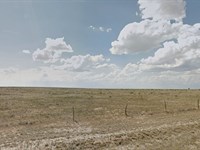
This 39.73 Acre Parcel is adjacent to over 8000 acres of BLM Land and situated roughly 5 miles from Dwight D. Eisenhower Hwy (80) and the town of Golconda in the Southeastern Corner of Humboldt County, Nevada. Roughly 42 miles from the town of Battle Mountain.
Located in Northwest Nevada, Humboldt County offers wide open spaces, beautiful mountains and valley vistas and a rich and fascinating history. Own your piece of the American west and enjoy all that this area has to offer, including Mining, agriculture, off road adventures, hiking, mountain biking and Hunting. Upland birds, record game and premium fishing are all nearby in the heart of Cowboy Country. This parcel is located within Hunt Unit 051.
Parcel Snapshot
Gps Marker: 40.8756, -117.4621
Legal Description: Sw1/4 Se1/4 of MAP Section 27 T35n R40e
Land Use Code: 100 - Vacant - Unknown/Other
Zone: M-3 Open Land Use District
Size: 39.73 Acres
Terrain: Varied
Tax District: 4.0 - Golconda Fire District
Power/Water: Rural / Off Grid
Property Taxes: $123.73/Yr
Hoa Fees: N/A
Be sure to reference L06376-1 in any correspondence.
$1 down payment and $199 document fee for lot L06376-1 in Nevada. Your welcome packet, contract, and payment coupon book for your monthly payments will be sent to the shipping address you provide. (Please note that we do charge a shipping fee.)
Ranch Maps & Attachments
Directions to Ranch
26 min (21.7 miles)
via I-80 W
Fastest route
40.8756, -117.4621
Take Rock Creek Rd to I-80 W
12 min (6.2 mi)
Follow I-80 W to NV-289 W/E 2nd St in Winnemucca. Take exit 178 from I-80 W
13 min (14.8 mi)
Turn left onto NV-289 W/E 2nd St
Continue to follow NV-289 W
2 min (0.7 mi)
Winnemucca
Nevada 89445
These directions are for planning purposes only. You may find that construction projects, traffic, weather, or other events may cause conditions to differ from the map results, and you should plan your route accordingly. You must obey all signs or notices regarding your route.
More Ranch Details
More Ranches from Ross Amato
 63.9 AC : $40K
- 10 AC : $9K
- 10 AC : $9K
- 38.4 AC : $20K
- 40 AC : $49.9K
- 37.6 AC : $20K
- 37.5 AC : $20K
- 39.7 AC : $25K
- 10 AC : $9K
- 10 AC : $9K
- 80.9 AC : $39.5K
- 44.7 AC : $25K