No Reserve Land Auction, 46 Acres
7601 Noland Road : Kansas City, MO 64138
Jackson County, Missouri
Ranch Description
Sells To The Highest Bidder Regardless Of Price.
46-Acres Commercial/Residential Land
Kansas City, Missouri
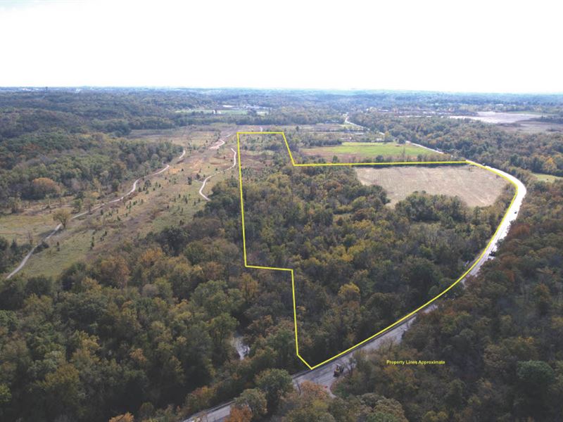
Discover this idyllic 46-acre parcel blending lush pasture and mature timber nestled alongside the serene Little Blue Valley Park presenting the perfect backdrop for commercial development, residential homes on small acreages or building your very own dream home. With level topography, all utilities to the site, paved road frontage, commercial and residential zoning, easy highway access and its location within a development priority zone, this land represents an exceptional investment opportunity and will be sold to the highest bidder regardless of price.
Superior Highway Access:
The property benefits from its easy access to 350 Highway with over 36K VPD and 40 Highway with over 20K VPD via Noland Road with over 7K Vpd. The significant traffic flow in the immediate area makes this property a great candidate for a variety of commercial and residential developments.
The Little Blue Valley Area Plan Shaping the Future:
• The plan calls for a major street connecting NW Gregory Blvd and E State Rte. 350 increasing activity at the northern boundary of the site.
• Per the plan, the property is located in a “Development Priority Zone” and falls between one “Major Activity Node” and two “Future Activity Nodes”. The city plans to focus on future development within these areas.
• The city has proposed an expansion of Noland Road to the west of the property boundary to 4 lanes to allow for greater traffic flow capability.
• The property is adjacent to Little Blue Valley Park, a 15.5-Mile hiking and bicycling trail with planned expansion to reach Longview Lake.
Zoning
According to the appraisal, the subject property is currently zoned R-80 residential and a portion is zoned M1-5 commercial industrial.
Frontage
According to the appraisal, the subject property offers 2200 feet ± of road frontage on Noland Road.
Utilities
According to the appraisal, all utilities are available to site including water, sewer, electricity, telephone and natural gas.
School District
According to the appraisal, the subject property is located within the Raytown School District.
Ranch Maps & Attachments
Directions to Ranch
From North: I-435 S to MO-350 (exit 66) continue east on MO-350 approx. 5 miles to Noland Rd., turn left and go approx. 1 mile to land on right.
From South: I-470 E. to MO-350 (exit 7B) toward Raytown, merge on US-50 W, keep left to continue on E State Route 350 for 2.5 miles to Noland Rd., turn right and go approx. 1 mile to land on right. Watch for signs.


