Caldwell Forest
Caldwell Road : Topsham, VT 05076
Orange County, Vermont
Ranch Description
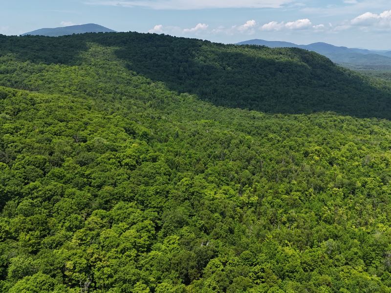
The property sports moderately sloping terrain, easily accessible and containing sites that would support a seasonal camp. Timber is generally high-quality and consists mostly of valuable sugar maple.
Notable highlights include:
- Several sites suitable for a seasonal or hunting camp close to Class 4 Roads and large public lands.
- High-quality timber resource dominated by sugar maple, with a total timber value of Sugarbush opportunity from a considerable sugar maple resource, accounting for 40% of total species composition.
- Largely gentle terrain supporting productive soils.
- Public Class 4 road frontage on two sides.
- Secluded location, yet close to major towns and amenities.
Location
Caldwell Forest is located in the rural town of Topsham, in the east-central region of Vermont. The area is a hilly section of the state between the spine of the Green Mountains to the west and the wide Connecticut River Valley to the east. The region is populated by small villages and hamlets in a working forest landscape. Scattered small farms can be found in most of the valleys, which also contain rivers such as the Wells and the Waits. The 26,000-Acre Groton State Forest lies to the northwest of the property and is an important regional public land base for outdoor recreation.
Topsham is a small town along the east-west VT Route 25 corridor that links the capitol city of Montpelier and Interstate 89 with Interstate 91 on the Vermont/New Hampshire border on its way to the Connecticut River. More extensive amenities can be found in Saint Johnsbury (30 miles northeast), Barre (21 miles west) or Bradford (24 miles southeast). From the property, Boston, Massachusetts, and Hartford, Connecticut, are both a 3-hour drive southeast and south, respectively.
Access
Legal access to Caldwell Forest is served via Class 4 roads. These roads, though generally not maintained by the town, offer legal, public access for capable vehicles with clearance, such as trucks, jeeps, and SUVs. Access is found via the Caldwell Road, which can be accessed from the south from Frost Road, or from the north via the Powder Spring Road. Caldwell Road forms the eastern boundary of the property, offering around 2,400' of Class 4 Road frontage. From here, many areas exist which are suitable for construction of a camp driveway, leading to sites for potential camp development. Skid trails and woods trails lead throughout the property.
Site Description
The property has been shaped by its former uses, including an intensive period of farming and homesteading going as far back as the late 1700S. Field evidence, including old stone walls and barbed wire, attests to the fact that this parcel was once used for pasturing and homesteading, before being abandoned and reverting to forest. Following abandonment, the site likely regenerated to early-successional species such as aspen and birch, which eventually gave way to maple species now found on the property.
The property is situated in the rolling hills and mountains, with the highest elevation point on the property being around 1,780' Asl, on the southern end of the property. From here, the property slopes down to the north. Slopes are very consistent throughout and are gradual to moderate, bottoming out at 1,660' ASL on the northern property boundary. The site is found to be highly variable in regard to drainage, with a wide range of conditions varying from well-drained to seepy in some areas. Small intermittent streams and ephemeral watercourses can be found throughout the forest, draining north and eventually draining into Powder Spring Brook. Soils on the property are productive, giving way to forests of sugar maple and yellow birch, and consist of Cabot and Buckland Series loams.
The site is easily accessed by timber harvesting equipment, and all acres are considered productive forestland.
The two-aged forest structure contains both mature hardwoods and younger poletimber and saplings, offering excellent current and future timber growth potential as well as wildlife habitat suitable for white-tailed deer, moose, bear, ruffed grouse, and numerous species of migratory songbirds. Significant amounts of moose signs were found on the property during the summer of 2024. Deer Wintering Areas can be found to the north of the property, as well as wetlands, which serve to draw wildlife to the area.
Logical campsites can be found in the southern reaches of the property, where easy access to public roads and flatter, well-drained sites present options for off-grid development.
Timber
Timber data in this report are based on a timber inventory conducted in December 2022, with the purpose of establishing Capital Timber Value (Ctv), by F&W Forestry Services, the owner's forest manager. 18 inventory points were sampled (1 plot per 4.5 acres), covering a 442' X 442' grid using a 15-factor prism. Sampling statistics are ±37.9% standard error for sawlog products at a 95% confidence interval. Upon applying growth for 1 season at regional FIA data growth rates, the timber data reveal a total sawlog volume of 398 MBF International ¼” scale (4.9 Mbf/Acre), with 1,109 pulpwood cords (13.7 cords/acre). Combined total commercial per acre volume is 18.2 cords, a figure about average for the region. Stumpage values were assigned to the volumes in May of 2024, producing a property-wide Capital Timber Value (Ctv) of acre). See the Timber Valuation in this report for details.
Species Composition:
The species composition is 90% hardwoods and 10% softwoods. Species composition for all products combined is led by sugar maple (60%), followed by white ash (10%), yellow birch (8%), spruce/fir (8%), and American beech (4%), with miscellaneous softwoods and hardwoods as associates. The sawlog volume breakdown is led by sugar maple (61%), followed by spruce/fir (13%), white ash (9%), and yellow birch (7%), along with small levels of various common associates. The primary species all have benefited from strong historical (and current) markets for their various end products, ensuring the likelihood of robust asset appreciation from stumpage price growth.
Stocking and Stem Quality:
Forest density is found to be adequate to well-stocked. The last timber harvest was conducted at least 10 years ago and resulted in a two-aged stand structure. The overstory is generally of high-quality hardwood sawtimber (77% Acceptable Growing Stock) and a dense understory consisting of productive northern hardwood saplings.
Sawlog Value/Management History:
Sawlog value is dominated by sugar maple (62%) followed by spruce/fir (13%), and white ash (9%), with the balance held by yellow birch, red maple, and others.
The 2023 forest management plan identifies two forest stands, of which both are dominated by northern hardwood timber. Both stands were harvested around 15 years ago utilizing a shelterwood treatment. The result is a high-quality and adequately stocked overstory atop a dense understory of northern hardwood saplings, mostly maple and birch species.
Diameter Distribution:
Average diameter for all products combined is 10.1”. The diameter distribution on the property is typical of managed forests of this type. Overstory timber features a variety of size classes, though is generally found to be consisting of sawtimber between 11-18”. Co-dominant, smaller-diameter timber represents a cohort waiting for release and future volume growth. Underneath, saplings and small pole-timber represent a large portion of the basal area, ranging from 2-6” in diameter.
Sugarbush Option
The timber data indicates a total of 2,950 potential maple taps from the 9” and greater size classes, with almost 100% of the taps from sugar maple. Tree health for sap production is very good, with most trees exhibiting healthy crowns and clean boles for tapping. Aspect is to the east, and is gentle to moderate overall, creating easy conditions for tapping and line setup. Electrical power does not currently run to the property, but the property is well-suited to off-grid maple setups or small-scale family sugaring operations.
